Abe River (Shizuoka Prefecture) Complete Guide: Thorough Explanation of History, Culture, and Geography from the Source to the Mouth of the Clear Stream
What is the Abe River?
The Abe River (あべかわ) is a first-class river flowing through Aoi Ward and Suruga Ward in Shizuoka City, Shizuoka Prefecture, and is the main stream of the first-class water system Abe River. It originates at Otani Ridge (elevation 1,997m), located on the border between Shizuoka Prefecture and Yamanashi Prefecture, and flows into Suruga Bay, with a total length of approximately 51-53.3 km.
With a drainage basin area of 567 km², it is a distinctive river known as one of Japan’s most rapid sediment-laden rivers. Its greatest characteristic is that, despite being a major river, it has no dams under the river law in either its main channel or tributaries—a rare phenomenon. This natural flow preserves its beauty as a clear stream, and its seepage water is utilized as tap water for Shizuoka City.
It boasts water quality that ranks in the top positions on the nationwide ranking of “rivers with clean water” every year, and serves as both an indispensable resource for local residents in their daily lives and an important role as a tourism resource.
Geography
Source and Water Source
The water source of the Abe River is Otani Ridge (elevation 1,997m), located near the border between Shizuoka City and Hayakawa Town and Minobu Town in Yamanashi Prefecture. Clear, crisp water gushing from this mountainous region marks the beginning of the Abe River. The upper reaches are located in deep mountain valleys and are surrounded by lush forests, creating the favorable water conditions.
Abe Pass (elevation 1,917m) is also considered one of the water source areas, with water flowing from this high elevation eventually growing into a major river.
Characteristics of the Drainage Basin
The Abe River has a distinctive geography where its main channel flows biased toward the east side of the drainage basin. Major tributaries such as the Nakakawachi River, Ashikubo River, and Warasina River all flow in from the west, forming the water system network of the entire basin.
Within the 567 km² drainage basin area, the upper reaches consist of steep mountainous terrain, the middle reaches flow through mountain gorges, and the lower reaches pass through the plains of Shizuoka City, with diverse topography continuing in succession. This change in topography creates the rich scenery of the Abe River.
Upper Reaches: Umegashima and Okawachi Region
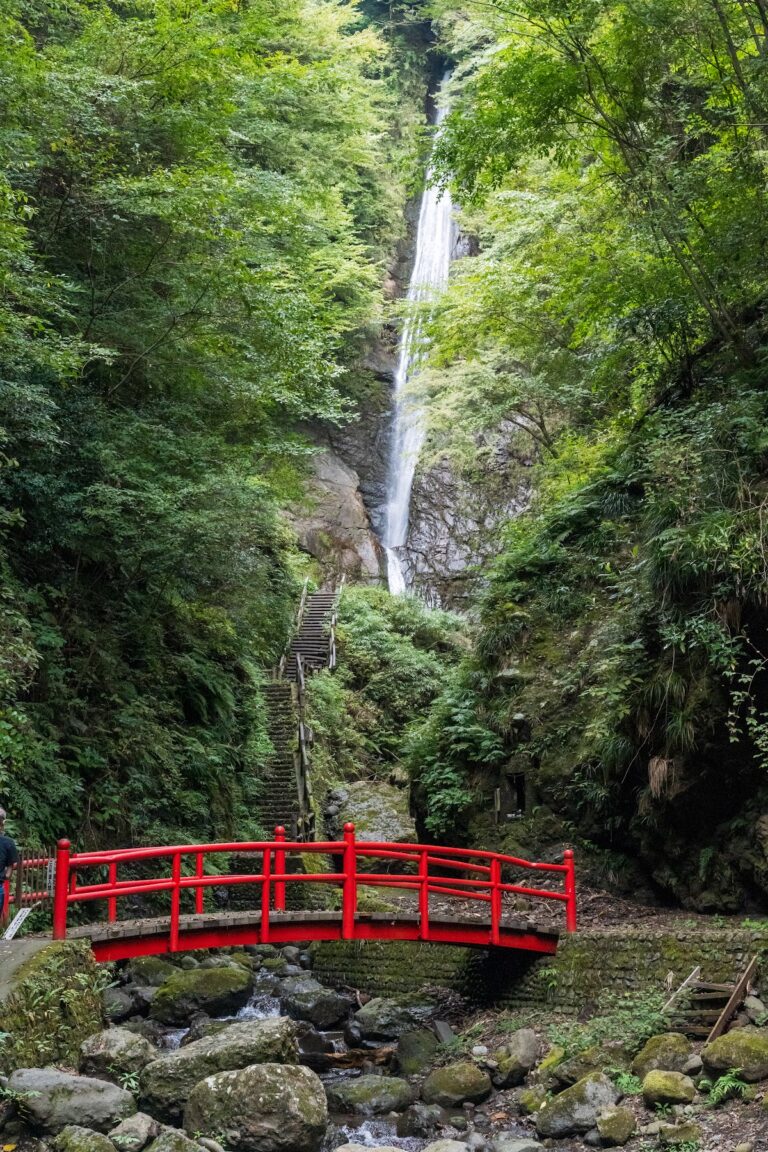
The upper reaches flow through mountainous areas such as Umegashima and Okawachi. This section features continuous steep gradients, with the characteristics of one of Japan’s most rapid rivers being particularly evident. The river gorge scenery can be enjoyed in this area, with tourist attractions such as Umegashima Hot Spring scattered throughout.
In the upper reaches, there is the Oya Collapse (おおやくずれ), one of Japan’s three major collapses, a large-scale failure zone. Parallel to Hiyedayama Collapse (Nagano Prefecture) and Tobi Mountain Collapse (Toyama Prefecture), this collapse zone symbolizes the geological characteristics of the Abe River basin. The combination of steep slopes and fragile geology has produced such large-scale collapses.
Middle Reaches: Until the Confluence with the Warasina River
In the middle reaches, the topography gradually shifts from gorge to more open terrain. In this section, multiple tributaries flowing in from the west merge with the main Abe River, increasing its water volume.
The Warasina River (わらしながわ), a major tributary, merges near Shizuoka City to the west. The Warasina River is the largest tributary in the Abe River system, with a river course of approximately 8.9 km (direct management section), contributing significantly to the Abe River’s water volume. The approximately 5 km from this confluence point to the river mouth constitutes the lower reaches.
Lower Reaches and River Mouth
The lower reaches flow through Shizuoka City and are characterized by open scenery with wide riverbeds. At the river mouth, the river flows into Suruga Bay, forming rich sandy beaches. The sand at the river mouth is the product of sediment transported from the upper reaches of the Abe River and is an interesting research subject in geology.
Approximately 22.7 km from the river mouth is designated as a direct national management section, managed by the Shizuoka River Office of the Chubu Regional Development Bureau of the Ministry of Land, Infrastructure, Transport and Tourism.
History
From Ancient Times to the Medieval Period
There are several theories about the origin of the name Abe River, but the theory that it derives from the Abe clan, who inhabited this region in ancient times, is the most prominent. In ancient times, it was also written as “Abe River,” suggesting deep connections with regional powerful clans.
In the medieval period, this river functioned as an important transportation route connecting Suruga Province and Kai Province. The roads along the river were used for transporting goods, playing a role in supporting the regional economy.
Edo Period: Connection with Tokugawa Ieyasu
Particularly important in the history of the Abe River is its connection with Tokugawa Ieyasu during the Edo period. Ieyasu, who based himself in Sumpu (present-day Shizuoka City), also devoted efforts to controlling the floods of the Abe River.
At that time, the Abe River was known as a wild river, with flood damage occurring frequently. Ieyasu ordered the construction of embankments, and it is said that he laid the foundation for the present river channel of the Abe River. This flood control project advanced development in the lower reaches and led to the growth of Shizuoka Town.
When the Tokaido road was developed, crossing the Abe River became an important gateway for travelers. No bridge was constructed over the Abe River, and crossing was accomplished by ferry workers. This was part of the bakufu’s defensive policy, and by not building a bridge, it maintained strategic importance as a military stronghold.
River Management Since Modern Times
From the Meiji period onward, modern river management began. Embankment construction for flood control and bank protection works were systematically implemented, shaping the present form of the Abe River.
With the high economic growth period in the Showa era, water pollution became a problem for a time, but through the efforts of local residents and administrative measures, water quality as a clear stream has been recovered and maintained. Currently, continuous river management by the Ministry of Land, Infrastructure, Transport and Tourism is being carried out, with efforts to balance disaster prevention and environmental conservation.
Culture of the Abe River
Abe River Mochi
What brought the name of the Abe River to nationwide attention is the Shizuoka Prefecture regional dish “Abe River Mochi.” This dish of freshly pounded rice cake coated with sugar-sweetened kinako (roasted soybean powder) is enjoyed as a specialty of central regions centered on Shizuoka City.
There are two theories about the origin of the name Abe River Mochi. One is the theory that Tokugawa Ieyasu named it. When Ieyasu was presented with Abe River mochi, he was so moved by its deliciousness that he ordered it be called by the river’s name.
The other theory is that it naturally came to be called “Abe River Mochi” because it was famous during the Edo period as a specialty sold at teahouses along the Abe River among people traveling the Tokaido road. In any case, this shows the deep connection between the Abe River and the region’s food culture.
Today, many shops in Shizuoka City offer Abe River Mochi, making it a popular souvenir among tourists.
Regional Beliefs and Legends
Water deity worship has been deeply rooted in the Abe River basin since ancient times. The custom of giving thanks for the river’s blessings and praying for protection from disasters such as floods has been passed down in regional festivals and events.
In settlements in the upper reaches, festivals praying for river safety are still held, becoming important community events. These cultural traditions tell the story of a long history of coexistence between the Abe River and its people.
Abe River in Literature and Art
The Abe River has been a subject in many literary works and paintings. In Edo period woodblock prints, the scenery of the Abe River is depicted as a famous scenic spot on the Tokaido. In Utagawa Hiroshige’s “Fifty-three Stations of the Tokaido,” travelers crossing the Abe River are depicted, conveying the situation of that time to the present day.
Since modern times, regional poets and writers have produced works with the Abe River as their subject, becoming an important element of Shizuoka’s cultural identity.
Main Tributaries
The Abe River system has many tributaries, each supporting the water resources of the basin.
Warasina River (わらしながわ)
The Warasina River is the largest tributary of the Abe River system, flowing in from the west. Its direct management section is approximately 8.9 km, and its confluence with the main Abe River is at a point about 5 km from the river mouth. The Warasina River itself has many tributaries and brings abundant water to the Abe River.
Tea fields spread throughout the Warasina River basin, known as a Shizuoka tea production area. Clear stream water contributes to the cultivation of high-quality tea and plays an important role in the regional economy.
Ashikubo River (あしくぼがわ)
The Ashikubo River is another important tributary that merges with the Abe River from the west. Flowing through the Ashikubo area, this river is also known as a clear stream, with rich natural scenery spreading throughout its basin.
Nakakawachi River
The Nakakawachi River is a tributary that merges with the Abe River in the upper reaches. This river, flowing through mountainous areas, has many rapid sections and offers scenic gorge views.
Other Tributaries
Various tributaries of different sizes, such as the Akiyama River and Maruko River, exist in the Abe River system. The gathering of these tributaries forms the abundant water volume of the Abe River. Individual river improvement plans have been formulated by prefectures and municipalities for each tributary, with comprehensive water system management being implemented.
Major Bridges
Many bridges span the Abe River, supporting regional transportation.
Abe River Bridge
The Abe River Bridge, which carries National Route 1, is the most important bridge with the highest traffic volume. As a major trunk road connecting east and west Shizuoka City, it carries numerous vehicles daily. The current bridge has modern structures and is designed with earthquake resistance in mind.
Ansei Bridge
One of the important bridges connecting the city center, it is utilized as a living road for local residents.
Tamaki Bridge (たまきばし)
Located in the middle reaches, Tamaki Bridge is known as a beautiful bridge that harmonizes with the surrounding landscape. The area around this bridge features wide riverbeds and serves as a place for citizens to relax.
Makigaya Bridge
Located in the upper reaches, Makigaya Bridge plays an important role connecting mountainous and urban areas. Near this point, the scenic gorge of the Abe River can be enjoyed.
Railroad Bridges
The railroad bridge where the JR Tokaido Main Line crosses the Abe River is also important infrastructure. Additionally, Abe River Station (575-66 Kamada, Suruga Ward, Shizuoka City, Shizuoka Prefecture) is located in the vicinity, serving as a hub for railway users.
Natural Environment and Ecosystem of the Abe River
Water Quality of the Clear Stream
The Abe River is known nationwide as a “river with clean water.” The absence of dams in the main channel and tributaries is a factor in maintaining natural water flow and water quality. This clear stream water is also utilized as a tap water source for Shizuoka City, being an important resource supporting residents’ lives.
Seepage water is abundant and contributes to the region’s groundwater resources. Water quality surveys consistently receive high evaluations, and it ranks in the upper positions in the Ministry of Environment’s water quality rankings.
Flora and Fauna
The clear stream ecosystem exists in the Abe River. Clear stream fish such as sweetfish, yamame trout, and red-spotted char inhabit the river, making it a popular fishing spot. Sweetfish fishing in particular has been passed down as a traditional regional culture.
Diverse plants grow on the riverbeds, presenting different appearances with the seasons. In spring, cherry blossoms; in summer, lush greenery; and in autumn, autumn colors can be enjoyed, offering seasonal natural beauty throughout the year.
Birds are also abundant, with water-loving species such as kingfishers, herons, and ducks being observable. It is an attractive spot for bird-watching enthusiasts.
Disaster Prevention and River Management
Flood Control Measures
The Abe River is a rapid river where rapid flooding can occur during heavy rain. The Shizuoka River Office of the Chubu Regional Development Bureau of the Ministry of Land, Infrastructure, Transport and Tourism implements continuous river management and disaster prevention measures.
Embankment construction and reinforcement, riverbed maintenance, and the operation of flood control facilities are implemented from multiple perspectives. Flood inundation hazard maps have been created and disclosed, helping to increase residents’ disaster prevention awareness.
Live Cameras and Surveillance Systems
Multiple live cameras are installed in the Abe River basin, allowing real-time confirmation of river conditions. There are numerous observation points, including those at the Shizuoka River Office, Tatsuki-cho Drainage Floodgate, Sakura-cho, Tsutsumi-cho, Fukudagaya, Kadoya, Shizuki, Ushitsuma Water Level Observation Station, Goshima, Tamaki Bridge, Makigaya Bridge, Shin’ma, and Nara-ma Water Level Observation Station.
This information is disclosed on weather and disaster prevention information sites such as “Cypos Radar,” allowing residents and related organizations to grasp river conditions. Real-time water level and rainfall information enable early evacuation decisions.
Sediment Management
The Abe River, as one of Japan’s most rapid sediment-laden rivers, carries large amounts of sediment from upstream. Proper management of this sediment is important for both maintaining the river environment and disaster prevention.
Riverbed maintenance and sediment deposit management are carried out while considering sediment discharge from collapse areas such as Oya Collapse. As preparation for sediment disasters, alert stations have been established (Yunoshima Alert Station, Hirano Alert Station, Sekinosawa Alert Station, etc.), with a surveillance system constructed.
Tourism and Recreation
Use of Riverbeds
The vast riverbeds of the Abe River serve as recreational spaces for citizens. Sports facilities, parks, walking paths, and other amenities have been developed, allowing for various activities such as jogging, cycling, and ball sports.
In particular, the riverbeds in the lower reaches offer open spaces that are crowded with many families on weekends. People enjoying barbecues and picnics are frequently seen.
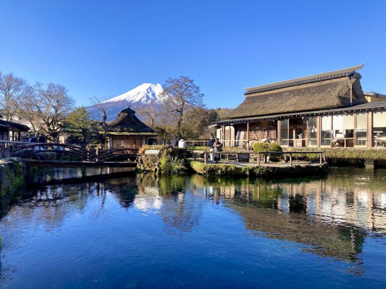
Umegashima Hot Spring District
In the Umegashima area of the upper reaches, there is a hot spring district where visitors can enjoy both the scenic gorge of the Abe River and hot springs simultaneously. It is a tourist destination where one can relax in a quiet environment surrounded by nature, away from urban hustle and bustle.
Access
Access to the Abe River takes approximately 30 to 130 minutes by bus from JR Shizuoka Station (time varies depending on destination). The lower reaches are easily accessible from the city center, while the upper reaches are typically accessed by route bus or private vehicle.
JR Tokaido Main Line’s Abe River Station (ticket sales office hours: 6:00-21:00) is also available, and connections with Shizutetsu Just Line buses are available.
Geological Characteristics
Characteristics as a Rapid Sediment-Laden River
The Abe River possesses interesting geological features as one of Japan’s most rapid sediment-laden rivers. With a large elevation difference from the source to the river mouth and continuous steep gradients, large amounts of sediment are transported.
This sediment transport capacity creates vast sandy beaches at the river mouth. The sand of the Abe River is composed of weathered and eroded rock from the mountains constituting the upper basin, and analyzing its composition provides clues for understanding the geological structure of the drainage basin.
Oya Collapse and Japan’s Three Major Collapses
As previously mentioned, there is the Oya Collapse, a large-scale failure zone in the upper Abe River basin. This is counted as one of Japan’s three major collapses, alongside Hiyedayama Collapse (Nagano Prefecture) and Tobi Mountain Collapse (Toyama Prefecture).
This collapse zone, which occurred from a combination of steep slopes and fragile geology, currently serves as a sediment source and has a major impact on the Abe River’s sediment dynamics. Geologically, it is a valuable natural record of orogenesis and erosion in the Japanese archipelago.
Geological Structure of the Drainage Basin
The Abe River basin has a complex geological structure. Multiple faults exist in the region, and seismic activity is active. This geological background has created steep topography and slopes prone to failure.
On the other hand, this complex geology has brought abundant groundwater resources and hot spring resources, forming the basis of the region’s natural environment and tourism resources.
Present-Day Abe River and Future Prospects
Sustainable River Management
Currently, sustainable river management is being pursued for the Abe River. The balance between strengthening disaster prevention functions and conserving the natural environment is an important issue.
In the river improvement plan by the Ministry of Land, Infrastructure, Transport and Tourism, management policies are defined from multiple perspectives, including flood control, water quality conservation, ecosystem maintenance, and promotion of residents’ use. Individual improvement plans have also been formulated for each tributary, including Akiyama River of the Abe River system.
Response to Climate Change
In recent years, extreme weather phenomena have increased due to climate change. The Abe River basin is also facing increased risks of rapid flooding and sediment disasters from concentrated rainfall.
In response, more advanced monitoring systems, faster transmission of evacuation information, updating of hazard maps, and other soft-side measures are being strengthened. Resident-participated disaster prevention drills are regularly conducted, and efforts are being made to improve disaster prevention capabilities throughout the region.
Utilization as a Regional Resource
The Abe River will continue to be utilized in various ways as an important regional resource for Shizuoka City in the future. Conservation of the clear stream increases its value as a tourism resource and water resource.
Additionally, promotion of riverbed use can contribute to residents’ health promotion and regional community revitalization. The Abe River also provides a valuable field for environmental education.
Inheritance of Culture
The inheritance of regional culture, such as Abe River Mochi, is also an important task. By passing on the history of the relationship between the river and people to the next generation, regional identity is maintained, leading to the realization of sustainable regional society.
Conclusion
The Abe River is a clear stream representative of Shizuoka Prefecture, possessing multifaceted value in geography, history, and culture. Originating from Otani Ridge and flowing into Suruga Bay over a course of approximately 51-53.3 km, it maintains natural flow characteristics while being a rapid sediment-laden river.
Within a drainage basin area of 567 km², many tributaries including the Warasina River merge, forming abundant water volume. From historical connection with Tokugawa Ieyasu, to food culture such as Abe River Mochi, and to modern disaster management, it has been inseparably linked with the region across time periods.
With water quality as a clear stream, a rich ecosystem, vast riverbeds, and hot spring resorts in the upper reaches, the Abe River possesses diverse attractions and has become an indispensable existence in the lives and culture of Shizuoka City residents. Through sustainable river management, it is our responsibility to pass this precious natural resource on to future generations.