Complete Guide to Tetori Shimizu (Tsukabori, Yokote City, Akita Prefecture)
Tetori Shimizu in Tsukabori, Yokote City, Akita Prefecture is a region surrounded by the rich nature of the Yokote Basin. With archaeological sites from the Yayoi period discovered here, it is a historic land where people have lived since ancient times, and it continues to preserve regional traditions today as an agricultural village centered on rice paddies.
This article provides comprehensive information about Tetori Shimizu, including its geographical features, historical background, transportation access, and surrounding facilities in detailed explanation.
Table of Contents
- Overview of Tetori Shimizu
- Geographical Features
- History and Cultural Heritage
- Number of Households and Population
- Transportation Access
- Surrounding Facilities and Living Environment
- School Districts for Elementary and Middle Schools
- Characteristics of the Tsukabori District as a Whole
- Tourism and Points of Interest
- Conclusion
Overview of Tetori Shimizu
Basic Information
Official Name: Tetori Shimizu, Tsukabori, Yokote City, Akita Prefecture (秋田県横手市塚堀字手取清水)
Postal Code: 013-0105
Location: Within the Tsukabori District, Yokote City, Akita Prefecture
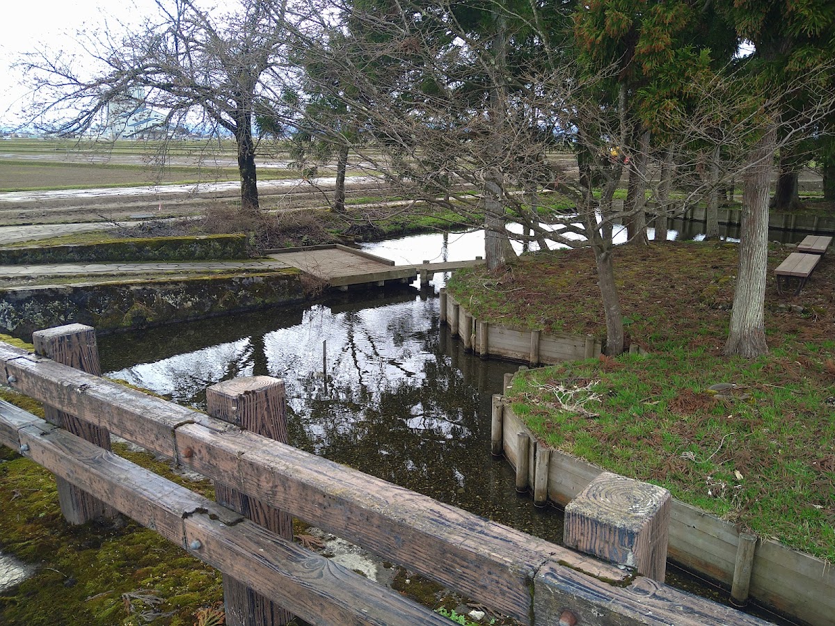
Tetori Shimizu is part of the Tsukabori District located in the northern part of Yokote City, and is a purely agricultural village area spreading across the northern side of the Yokote Basin in central Akita Prefecture. The place name “Tetori Shimizu” is believed to derive from clear spring water and water sources, reflecting the abundance of water resources in the region.
Address Notation and Lot Numbers
The Tetori Shimizu district includes mainly the following lot numbers:
- 55 Tetori Shimizu, Tsukabori, Yokote City, Akita Prefecture
- 57 Tetori Shimizu, Tsukabori, Yokote City, Akita Prefecture
These lot numbers are primarily used for residences and farmland, forming the foundation of the lives of local residents.
Geographical Features
Topography and Natural Environment
Tetori Shimizu is located in the northern part of the Yokote Basin and is characterized by relatively flat terrain. The surrounding area is a vast rice paddy region, forming part of Akita Prefecture’s representative granary.
Elevation: Approximately 50-70 meters
Topography: Alluvial plains, low-lying areas along rivers
Climate: It belongs to the Japan Sea climate type, with heavy snowfall in winter and relatively warm summers. Annual precipitation is around 1,500mm, with distinct seasonal changes.
Water Systems and Water Resources
As suggested by the character “shimizu” (spring water) in the place name, this region is blessed with high-quality groundwater and springs. Tributaries of rivers flowing through the Yokote Basin and irrigation channels are used as agricultural water, supporting the region’s rice cultivation.
Clear water has long been used as domestic water supply, becoming an indispensable resource for the lives of local residents.
Land Use
Land use in the vicinity of Tetori Shimizu is classified as follows:
- Agricultural Land: Approximately 70% (primarily rice paddies)
- Residential Land: Approximately 15%
- Other (roads, waterways, etc.): Approximately 15%
It is a purely agricultural village centered on rice paddies, retaining strong characteristics as a rice-producing region representative of Akita Prefecture.
History and Cultural Heritage
Tetori Shimizu Archaeological Site
The most important historical asset of the Tetori Shimizu district is the Tetori Shimizu Archaeological Site. This site was discovered as a settlement from the Middle Yayoi period (approximately 3rd century BCE to 1st century CE).
Discovery Period: Confirmed through excavation surveys in the latter Showa period
Site Characteristics:
- Dwelling ruins from the Middle Yayoi period
- Pottery and stone tools and other daily implements
- Structures indicating the settlement layout of the time
The Yokote Basin in the Yayoi Period
During the Middle Yayoi period when the Tetori Shimizu site existed, the Yokote Basin is believed to have had a colder climate than the present. For this reason, the rice cultivation culture that thrived in Western Japan had not yet become sufficiently established in this region, and large-scale settlements were rare.
However, the existence of the Tetori Shimizu site provides valuable evidence that people lived in this area even under harsh environmental conditions. The lifestyle of people at the time, centered on hunting and gathering while gradually incorporating agricultural culture, can be understood from the archaeological remains.
Development Since Modern Times
During the Edo period, the region came under the control of the Akita Domain and was developed as an agricultural area. With the abolition of the han system and establishment of prefectures in the Meiji period, it was incorporated into Akita Prefecture. On November 26, 1951, it became part of Yokote City.
On October 1, 2005, Yokote City merged with Masuda Town, Taira-ka Town, Omonogawa Town, Omori Town, Jumonji Town, Yamanouchi Village, and Taio Village, creating the new Yokote City. Through this merger, Tetori Shimizu became part of the current Tsukabori District of Yokote City.
Historical Background of Tsukabori District
The Tsukabori District, to which Tetori Shimizu belongs, contains other important sites. In particular, the Ohon Shimizu Archaeological Site is known as a Jomon period site, indicating that this region has been a place where people lived since ancient times.
The place name “Tsukabori” itself may derive from ancient burial mounds or tumuli, evoking a sense of the accumulation of history from ancient times.
Number of Households and Population
Population Dynamics
The Tsukabori District, which includes Tetori Shimizu, like Akita Prefecture as a whole, is experiencing population decline and aging.
Estimated Number of Households: Approximately 10-20 households (Tetori Shimizu district)
Estimated Population: Approximately 30-50 people (Tetori Shimizu district)
Characteristics of Population Composition
- Aging Rate: Approximately 40-50% (estimated)
- Household Composition: Primarily farming households, with some three-generation households
- Population Trend: Gradual declining trend
In the purely agricultural village of Tetori Shimizu, many households engage in farming, and traditional regional communities are maintained. However, the outflow of young people to urban areas has created challenges with the shortage of successors.
Regional Community
Despite being a small settlement, the bonds among local residents are strong, with joint agricultural work and maintenance of community events demonstrating a spirit of mutual support.
Transportation Access
Nearest Bus Stops
Access to Tetori Shimizu is available via the following bus stops:
Tsukabori Bus Stop
- Distance: Approximately 159m (nearest)
- Operation: Ugo Transportation Bus
- Route: Connection with Yokote Station area
Nurii’no Bus Stop
- Distance: Approximately 607m
- Operation: Ugo Transportation Bus
Mizukoshi Bus Stop
- Distance: Approximately 679m
- Operation: Ugo Transportation Bus
Major Roads
Prefectural and Municipal Roads: Municipal roads passing through the Tsukabori District serve as the main access roads.
National Route 13: A major trunk road running north-south through the center of Yokote City, approximately 10-15 minutes by car from the Tsukabori District.
Railway Access
Nearest Station: “Yokote Station” on the JR Ou Main Line and Kitakami Line
- Distance: Approximately 8-10 km
- Travel Time: Approximately 15-20 minutes by car, 25-30 minutes by bus
Yokote Station is approximately 20 minutes from Omagari Station, a stop on the Akita Shinkansen, and approximately 1 hour from Akita Station, serving as an access hub to areas within and outside the prefecture.
Access by Automobile
Akita Expressway “Yokote IC”
- Distance: Approximately 10-12 km
- Travel Time: Approximately 15-20 minutes
Automobile access is the most convenient, with most local residents using private cars.
Distance from Major Cities:
- Yokote City Center: Approximately 8 km (15 minutes by car)
- Akita City: Approximately 70 km (approximately 1 hour by car)
- Sendai City: Approximately 200 km (approximately 2 hours 30 minutes by car)
Surrounding Facilities and Living Environment
Commercial Facilities
As a purely agricultural village, the Tetori Shimizu area has no large commercial facilities. Daily shopping is typically done at commercial facilities in the center of Yokote City.
Nearest Major Commercial Facilities:
- Aeon Super Center Yokote Minami Store: Approximately 20 minutes by car
- York Benimaru Yokote Store: Approximately 15 minutes by car
- Michi-no-Eki Jumonji: Approximately 15 minutes by car
Medical Institutions
Nearest Medical Institutions:
- General hospitals in Yokote City: Approximately 15-20 minutes by car
- Local clinics: Approximately 10-15 minutes by car
In emergencies, general hospitals such as Yokote City Yokote Hospital and Taira-ka General Hospital are available.
Public Facilities
Yokote City Hall: Approximately 15 minutes by car
Tsukabori District Community Center: Used as a local meeting hall
Financial Institutions
Banks and ATMs are concentrated in the center of Yokote City.
- Akita Bank Yokote Branch
- Hokuto Bank Yokote Branch
- Ugo Credit Union Yokote Branch
Post Office
Yokote Post Office: Approximately 15 minutes by car (Postal Code: 013-8799)
Postal services are available through simple post offices and delivery points within the region.
School Districts for Elementary and Middle Schools
School District Information
Pupils and students in the Tetori Shimizu area, which is part of the Tsukabori District, attend the following schools:
Elementary School: Yokote Minami Elementary School, Yokote City (school consolidation possible)
- Distance: Approximately 5-8 km
- Transportation: School bus
Middle School: Yokote Minami Middle School, Yokote City
- Distance: Approximately 8-10 km
- Transportation: School bus
Educational Environment
School consolidations are progressing due to the declining birthrate, but Yokote City is making efforts to enhance the educational environment. School bus operations ensure that pupils and students in agricultural areas can commute safely.
High Schools:
- Akita Prefectural Yokote High School: Approximately 20 minutes by car
- Akita Prefectural Yokote Seiryoin High School: Approximately 20 minutes by car
- Akita Prefectural Yokote Jonan High School: Approximately 20 minutes by car
Characteristics of Tsukabori District as a Whole
Overview of Tsukabori District
The Tsukabori District, to which Tetori Shimizu belongs, is an ōaza (large subdivision) located in the northern part of Yokote City. It is a purely agricultural village centered on rice paddies, preserving the traditional agricultural landscape characteristic of Akita Prefecture.
Major Aza (Subdivisions)
In addition to Tetori Shimizu, the Tsukabori District contains multiple subdivisions:
- Ohon Shimizu: Known for the Ohon Shimizu archaeological site from the Jomon period
- Ohon Shimizu North: Located north of Ohon Shimizu
- Tetori Shimizu: Contains the Tetori Shimizu archaeological site from the Yayoi period
These place names share the common character “shimizu” (spring water), indicating that this region was blessed with abundant water resources.
Agricultural Characteristics
The Tsukabori District is one of Akita Prefecture’s representative rice-producing areas.
Main Crops:
- Paddy rice (Akitakomachi, etc.)
- Vegetables (Japanese leek, cabbage, etc.)
- Fruits (Apples, etc.)
Taking advantage of the fertile soil of the Yokote Basin and abundant water resources, high-quality rice production is carried out. In recent years, efficient farming by large-scale agricultural corporations has also progressed.
Regional Events and Traditions
The following traditional events are passed down in the Tsukabori District:
- Kamakura: A winter tradition held throughout Yokote City
- Bon Odori: Summer community events
- Shrine Festivals: Celebrations honoring the local guardian deity
Through these events, the bonds among local residents are maintained.
Tourism and Points of Interest
Tetori Shimizu Archaeological Site
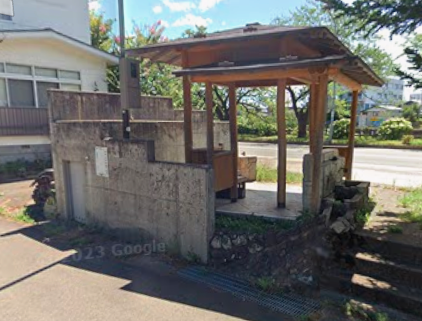
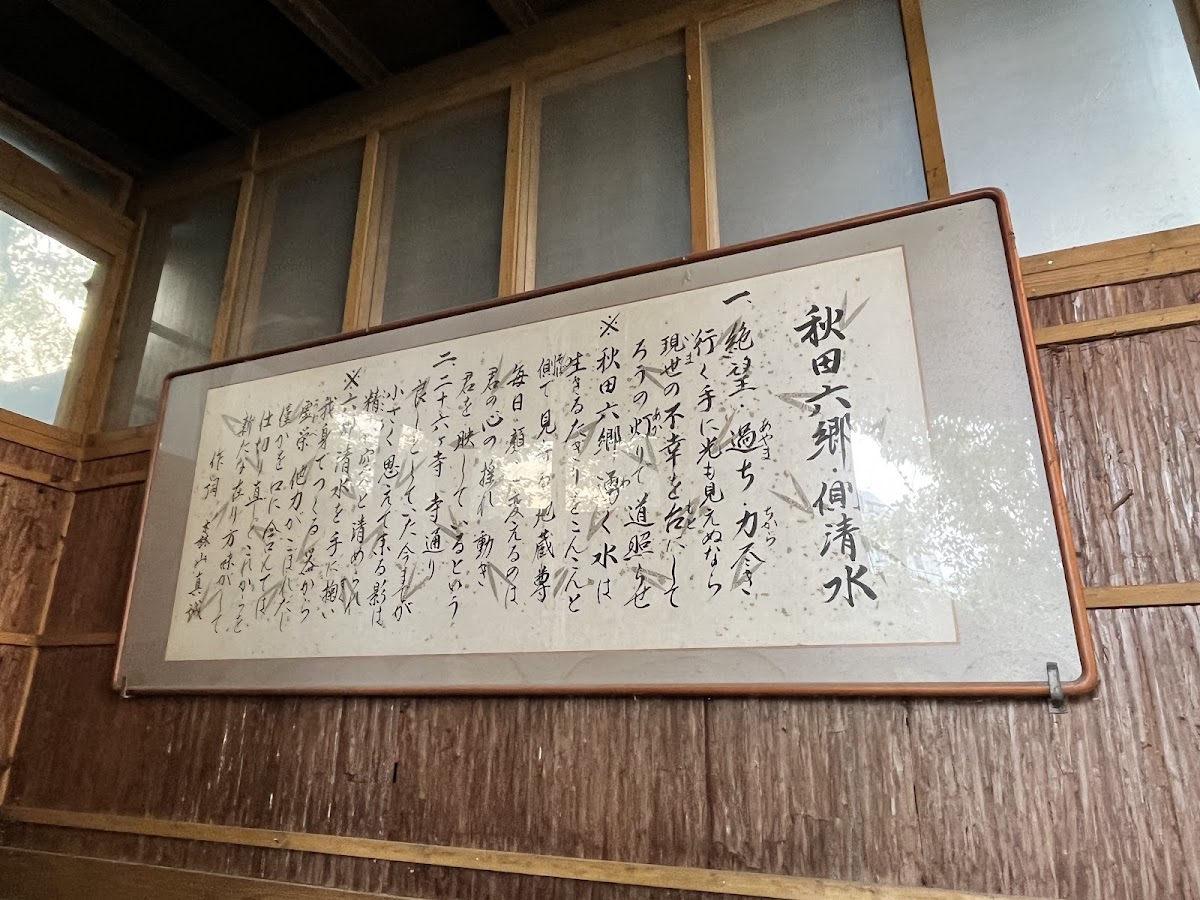
The Tetori Shimizu archaeological site, a Yayoi period settlement, is an interesting spot for history enthusiasts. Information boards may be installed at the site (to be confirmed).
Surrounding Tourist Attractions
Major tourist sites in Yokote City accessible by car from Tetori Shimizu:
Yokote Castle (Yokote Park)
- Distance: Approximately 15 minutes by car
- Features: Symbol of Yokote City, famous for cherry blossoms
Yokote City Fureai Center Kamakura-kan
- Distance: Approximately 15 minutes by car
- Features: Facility where visitors can experience kamakura year-round
Masuda Storehouses
- Distance: Approximately 20 minutes by car
- Features: Important Preservation District for Groups of Historic Buildings
Akita Furusato Village
- Distance: Approximately 20 minutes by car
- Features: Theme park introducing Akita culture and products
Seasonal Scenery
Spring: Water is drawn into the rice paddies, creating a beautiful mirror-like landscape.
Summer: Lush green rice sways in the wind, with verdant rice paddies spreading like a carpet.
Autumn: Rice ripening to golden hues announces the joy of harvest.
Winter: A blanket of snow creates a serene beauty. During the Yokote Kamakura Festival season, visitors can enjoy the fantastical atmosphere of snowy countryside scenery.
Living Information
Climate and Clothing
Tetori Shimizu and the surrounding Yokote City area belong to the Japan Sea climate type, characterized by heavy winter snowfall.
Average Annual Temperature: Approximately 10-11°C
Annual Precipitation: Approximately 1,500 mm
Snowfall: December to March, with maximum snow depth of approximately 1-2 meters
Warm clothing and waterproof shoes are essential for winter visits.
Relocation and Settlement Information
Yokote City offers various support systems to promote relocation and settlement:
- Housing acquisition support
- Vacant house bank
- Farming support
- Childcare support
For details, please contact the Relocation and Settlement Promotion Division of Yokote City Hall.
Internet Environment
Fiber optic infrastructure is expanding, with high-speed internet available in many areas.
Regional Challenges and Outlook
Current Challenges
- Population Decline and Aging: Declining regional vitality due to outflow of young people
- Shortage of Agricultural Successors: Shortage of agricultural workers due to aging
- Infrastructure Maintenance: Maintenance management of roads, waterways, and other facilities
- Quality of Life: Access to commercial facilities and medical institutions
Future Prospects
Yokote City is pursuing the following initiatives:
- Promotion of Smart Agriculture: Efficient agriculture using ICT technology
- Sixth Industrialization: Value-added agricultural production, processing, and sales
- Tourism Promotion: Tourism development utilizing historical heritage and natural features
- Immigration Promotion: Enhanced support for U, I, and J-turn migration
Through these initiatives, sustainable development of the Tsukabori District, including Tetori Shimizu, is expected.
Conclusion
Tetori Shimizu in Tsukabori, Yokote City, Akita Prefecture is a historic land where people have lived since ancient times, as evidenced by archaeological sites from the Yayoi period. Blessed with abundant water resources and fertile soil, it has developed as a major rice-producing region representative of Akita Prefecture.
Currently facing challenges such as population decline and aging, the region maintains its traditional agricultural landscape and strong regional community while adapting to the new era.
Tetori Shimizu, a quiet agricultural village in the northern part of Yokote City, is a charming area where beautiful rural scenery, often called the original landscape of Japan, and history from ancient times come alive. When visiting Yokote City, be sure to experience the abundant nature and history of this region.
References
- Yokote City Official Website
- Akita Prefecture Official Website
- “Yokote City History” Yokote City History Compilation Committee
- GSI Map Information
- Akita Prefectural Education Board “Archaeological Sites in Akita Prefecture”
- Various statistical materials (Census, etc.)
Related Items
- Yokote City
- Tsukabori
- Ohon Shimizu Archaeological Site
- Yokote Basin
- Yayoi Period
- History of Akita Prefecture
- Yokote’s Kamakura
- Akitakomachi
—
※The information in this article is current as of 2024. For the latest information, please contact Yokote City Hall or relevant organizations.